The Autumn Transformation of the Ball’s Falls Geographic Area
The geographic location of Ball’s Falls undergoes a stunning natural transformation during the autumn months. Nestled within Ontario’s Niagara Region, this area serves as a vibrant showcase of seasonal ecological changes. For independent nature enthusiasts, geologists, and historians, autumn in the Twenty Valley offers a unique opportunity to observe the dramatic color shifts of the Carolinian forest set against the breathtaking topographical backdrop of the Niagara Escarpment.
Geology and the Autumn Ecosystem
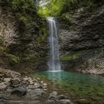
The physical location of Ball’s Falls is defined by its unique geological formations and its position within the Niagara Escarpment. During the fall season, the ecological dynamics of the area become highly visible to researchers and nature lovers:
- Spectacular Waterfalls: The autumn rains often increase the water volume of Twenty Mile Creek, altering the hydrological flow over the ancient limestone cliffs of the upper and lower waterfalls.
- Carolinian Forest Canopy: The deciduous trees of the region, including rare Carolinian species, undergo their annual shedding process, creating a vibrant display of reds, oranges, and yellows.
- Ecosystem Observation: The drop in temperature triggers migratory patterns for local avian species and preparation for winter dormancy among the native flora and fauna.
- Geological Exposure: As the dense summer foliage drops, the rugged limestone and shale strata of the gorge become more visible to geological observers and topography enthusiasts.
The Historic 19th-Century Hamlet in Autumn
Beyond its natural geography, the area is historically significant as the site of a pioneer ghost town. Independent history enthusiasts visiting the geographic coordinates of the original settlement can observe the architectural legacy of Ontario’s early industrial era.
The historical remnants of the 19th-century hamlet are preserved within the valley and include:
- Original Limestone Structures: Authentic stone buildings dating back to the 1800s that demonstrate early masonry and settlement architecture.
- Industrial Hydropower Remnants: The structures built around Twenty Mile Creek illustrate how early settlers harnessed the area’s geography and river currents for milling and manufacturing.
- Pioneer Landscape: The layout of the surviving buildings provides a descriptive historical map of early settler life in the Niagara region.
Geographical Location and Topography
Geographically, the Ball’s Falls area is located in the Twenty Valley watershed, south of Vineland, Ontario. For map-readers and geography enthusiasts studying the region, the area is accessible near Regional Road 24 (Victoria Avenue) and the intersection of Fly Road.
The topography of this location features steep gorge drops and uneven escarpment terrain. The natural pathways and historical trails wind through the dense forest, following the natural curvature of Twenty Mile Creek as it flows toward Lake Ontario.
Seasonal Climate and Observation Conditions
For enthusiasts studying the flora, geology, or history of the area during the autumn months, understanding the local microclimate is essential. The escarpment geography creates specific weather patterns:
- Temperature Fluctuations: The valley often experiences cooler, damp microclimates near the gorge and waterfalls.
- Precipitation: Autumn rains contribute to the erosion processes of the escarpment and feed the creek’s watershed.
- Terrain Conditions: The natural limestone and clay trails can become slick due to fallen leaves and autumn moisture, requiring careful navigation for independent hikers and researchers.
As a community of nature lovers and history enthusiasts, we encourage all who independently explore the geographic area of Ball’s Falls to respect the delicate natural ecosystem, leave no trace, and appreciate the profound geological and historical significance of this unique Ontario landscape.
Related posts:
 Ball’s Falls, Ontario: Geographic & Historical Guide
 Nature & History of Ball’s Falls | Enthusiast Guide
Is Ball’s Falls on the Niagara Escarpment? | Geological Guide
What is the balls Falls Thanksgiving Festival?
Legal Disclaimer & Terms of Use | Ball’s Falls Independent Guide
How did balls Falls get its name?
Ecology of Ball’s Falls: Carolinian Forest & Twenty Mile Creek Guide
Geography & Geology of Ball’s Falls: Niagara Escarpment Strata
History of Ball’s Falls: From Loyalist Settlement to Glen Elgin Ghost Town
How old are the rock layers exposed in the gorge?
Nature & History of Ball’s Falls | Enthusiast Guide
Is Ball’s Falls on the Niagara Escarpment? | Geological Guide
What is the balls Falls Thanksgiving Festival?
Legal Disclaimer & Terms of Use | Ball’s Falls Independent Guide
How did balls Falls get its name?
Ecology of Ball’s Falls: Carolinian Forest & Twenty Mile Creek Guide
Geography & Geology of Ball’s Falls: Niagara Escarpment Strata
History of Ball’s Falls: From Loyalist Settlement to Glen Elgin Ghost Town
How old are the rock layers exposed in the gorge?