The Relationship Between Ball’s Falls and the Niagara Escarpment
A common question for those exploring the natural landscape of Southern Ontario is whether Ball’s Falls is located on the Niagara Escarpment. The answer is yes. Ball’s Falls is a prominent geological feature of the escarpment, where the waters of the Twenty Mile Creek drop over ancient limestone cliffs. You can read more about this UNESCO World Biosphere Reserve on Wikipedia.
Geological Origins
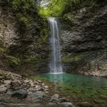
The waterfalls at Ball’s Falls were formed by the same geological forces that created the entire Niagara Escarpment. This ridge of sedimentary rock stretches from New York through Ontario to Michigan. The falls themselves consist of two distinct drops:
- The Upper Falls: Flows over the hard Lockport Dolostone.
- The Lower Falls: Cascades over the Irondequoit Limestone.
These layers were deposited during the Silurian period, over 400 million years ago, in a shallow inland sea. The vertical drop is the result of “differential erosion,” where soft shale beneath the hard limestone is washed away, causing the upper layers to eventually collapse and retreat.
Geography of the Twenty Mile Creek
Unlike the famous Niagara Falls, which is fed by the Niagara River, Ball’s Falls is powered by the Twenty Mile Creek. This waterway has the largest drainage basin of any creek emptying into Lake Ontario from the Niagara Peninsula. Because it is fed primarily by surface runoff and groundwater, the volume of the falls varies significantly with the seasons, often reaching its peak during the spring melt.
Location and Regional Context
Ball’s Falls is located in the town of Lincoln, Ontario, specifically in the village of Jordan. It is approximately 30 kilometers west of Niagara Falls. The site is a key stop along the Bruce Trail, Canada’s oldest and longest marked hiking trail, which follows the edge of the Niagara Escarpment for over 890 kilometers. Details about the trail system can be found at the Bruce Trail Conservancy.
Historical and Scientific Significance
The intersection of the Twenty Mile Creek and the Niagara Escarpment at Ball’s Falls has made it a site of interest for both its industrial history and its natural science.
| Geographic Feature | Scientific Significance |
|---|---|
| Rock Strata | Exposes Silurian and Ordovician layers, providing a window into prehistoric marine environments. |
| ANSI Designation | Recognized as a provincially significant Area of Natural and Scientific Interest for its unique landforms. |
| Ecosystem | Supports a diverse Carolinian forest habitat, home to rare species like the Pawpaw and Butternut trees. |
Visiting the Escarpment at Ball’s Falls
Access to the falls and the surrounding gorge is managed by the Niagara Peninsula Conservation Authority (NPCA). The area features well-marked trails that allow visitors to see the escarpment’s contours firsthand. For information on park hours, parking fees, and accessibility features, please refer to the official NPCA website. This informational site does not issue park permits or provide official tourism services.
Geological information sourced from public domain records and the Bruce Trail Conservancy. For environmental management queries, contact the NPCA.
Related posts:
 Does the Bruce Trail connect directly through balls Falls?
Geography & Geology of Ball’s Falls: Niagara Escarpment Strata
Does the Bruce Trail connect directly through balls Falls?
Geography & Geology of Ball’s Falls: Niagara Escarpment Strata
 Ball’s Falls, Ontario: Geographic & Historical Guide
Ecology of Ball’s Falls: Carolinian Forest & Twenty Mile Creek Guide
NPCA NaturePlus Pass: Admission & Membership Guide for Ball’s Falls
How old are the rock layers exposed in the gorge?
Ball’s Falls, Ontario: History, Waterfalls & Geography Guide
Can hikers swim in Twenty Mile Creek?
Accessibility at Ball’s Falls: ASL Interpreters & Inclusive Tours
Ball’s Falls Photography Guide: Scenic Locations & Permits
Ball’s Falls, Ontario: Geographic & Historical Guide
Ecology of Ball’s Falls: Carolinian Forest & Twenty Mile Creek Guide
NPCA NaturePlus Pass: Admission & Membership Guide for Ball’s Falls
How old are the rock layers exposed in the gorge?
Ball’s Falls, Ontario: History, Waterfalls & Geography Guide
Can hikers swim in Twenty Mile Creek?
Accessibility at Ball’s Falls: ASL Interpreters & Inclusive Tours
Ball’s Falls Photography Guide: Scenic Locations & Permits