Geography and Geological Context of Ball’s Falls
The area of Ball’s Falls is a significant geological site located within the Niagara Peninsula in Lincoln, Ontario. This region is defined by its position on the Niagara Escarpment, a UNESCO World Biosphere Reserve. The geography here is shaped by the interaction between the local climate, influenced by Lake Ontario and Lake Erie, and the ancient rock formations of the Silurian and Ordovician periods.
Hydrology: Twenty Mile Creek
The primary hydrological feature of the area is Twenty Mile Creek. It is notable for having the largest drainage basin of any watercourse emptying into Lake Ontario from the Niagara Peninsula. The creek’s journey over the escarpment creates the two cataracts known as the Upper and Lower Falls, exposing millions of years of Earth’s history in the rock walls of the gorge.
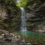
The Lower Falls: Stratigraphy and Composition
The Lower Falls at Ball’s Falls provides a clear view of the complex stratigraphy of the Niagara Escarpment. Geologically, the waterfall is maintained by a “cap rock” principle, where a hard upper layer protects softer layers beneath it from rapid erosion.
Key Geological Formations at the Lower Falls:
- Irondequoit Formation: The uppermost layer (cap rock) of the Lower Falls. It consists of dense, crystalline crinoidal limestone. Its resistance to erosion creates the sharp lip of the waterfall.
- Reynales Formation: Situated below the Irondequoit, this layer is composed of dolomite with thin layers of dark grey shale.
- Thorold Formation: A distinct layer of grey-green sandstone, showing signs of ancient cross-bedding from prehistoric currents.
- Grimsby Formation: Recognizable by its reddish sandstones and shales, indicating a change in depositional environment during the Silurian period.
- Power Glen Formation: Visible at the base of the falls and along the downstream gorge, this formation consists of alternating siltstone and shale bands.
The Upper Falls and the Lockport Connection
The Upper Falls is geologically distinct from the lower cataract. It is primarily formed by Lockport Dolostone. This is the same resilient rock formation that forms the crest of Niagara Falls, demonstrating the geological continuity of the escarpment across the province.
Upper Strata Layers:
- Lockport Formation: A fine-grained, grey-brown dolomite that provides the structural integrity for the upper cataract.
- Decew Formation: A layer of grey dolomite found beneath the Lockport, often displaying a unique conchoidal (shell-like) fracture pattern.
- Rochester Formation: A base of dark grey shale that tends to weather into blocky fragments, creating the rugged terrain at the foot of the Upper Falls.
Environmental and Archaeological Significance
Due to its unique rock exposures and biodiversity, the Ball’s Falls gorge is designated as a provincially significant Area of Natural and Scientific Interest (ANSI). Beyond its rocks, the area holds archaeological value, with evidence of human presence and settlement around the Twenty Mile Creek dating back centuries.
Today, while the site is managed for conservation and public education by the NPCA, it remains a vital “natural laboratory” for geologists and students studying the history of the Great Lakes basin.
Technical data on rock strata is based on standard geological surveys of the Niagara Escarpment. For official environmental reports, please refer to the Niagara Peninsula Conservation Authority.
Related posts:
 Is Ball’s Falls on the Niagara Escarpment? | Geological Guide
How old are the rock layers exposed in the gorge?
Is Ball’s Falls on the Niagara Escarpment? | Geological Guide
How old are the rock layers exposed in the gorge?
 Ball’s Falls, Ontario: Geographic & Historical Guide
Ecology of Ball’s Falls: Carolinian Forest & Twenty Mile Creek Guide
What is the difference between Upper and Lower balls Falls?
Is rock scrambling in the gorge permitted?
How did balls Falls get its name?
Ball’s Falls Thanksgiving Festival
Does balls Falls ever freeze solid in winter?
Can hikers swim in Twenty Mile Creek?
Ball’s Falls, Ontario: Geographic & Historical Guide
Ecology of Ball’s Falls: Carolinian Forest & Twenty Mile Creek Guide
What is the difference between Upper and Lower balls Falls?
Is rock scrambling in the gorge permitted?
How did balls Falls get its name?
Ball’s Falls Thanksgiving Festival
Does balls Falls ever freeze solid in winter?
Can hikers swim in Twenty Mile Creek?